
Many people visited Massachusetts prior to colonization. Most of these people were traders and fishermen looking to harvest valuable resources like fish, whales and furs while others were explorers looking either for a place to establish a colony or for a passageway to the east.
One of the earliest explorers to visit North America was an Italian named John Cabot who journeyed to the continent at the request of Henry VII of England in 1497. Yet, it is not entirely clear where he visited, most likely either Maine or Newfoundland, or how much of New England he explored.
Yet, it was John Cabot’s expedition to North America that allowed England to claim the continent for the crown and led to English colonization in the 17th century.
While there is also a theory that Portuguese explorer Miguel Corte-Real visited Massachusetts in 1511, due to the fact that some mysterious carvings on Dighton Rock in Berkley possibly bear his name, there is no definitive proof of him being there.
There were many other explorers who visited New England and Massachusetts though and their journeys are well documented.
The following is a list of people who explored Massachusetts:
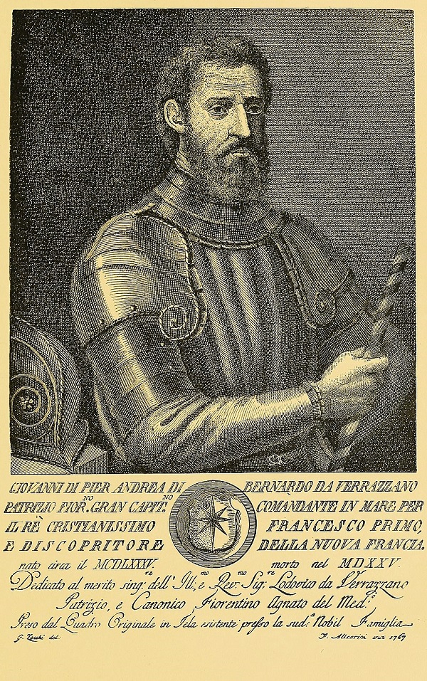
Giovanni da Verrazzano:
In 1524, an Italian navigator exploring for France, named Giovanni da Verrazzano, sailed along and mapped the east coast of North America from the Carolinas up to Newfoundland.
Verrazzano had been commissioned by King Francis I of France to find a Northwest passage to Asia in 1523.
In January of 1524, Verrazzano set sail from Dieppe, France and reached Cape Fear in North Carolina in March before sailing north and exploring the eastern coast of North America, looking for a waterway to the Pacific Ocean.
Verrazzano and his crew stopped in several locations, such as North Carolina and Rhode Island, and made friendly contact with the local natives there.
Then they continued sailing north where they reached Cape Cod and sailed past the large shoal east of Nantucket, which Verrazzano nicknamed Armellini, according to a letter he wrote to the king:
“within this distance we found sandbanks which stretch from the continent fifty leagues out to sea. Over them the water was never less than three feet deep: thus there is great danger in sailing there. We crossed them with difficulty and called them ‘Armellini.’”
Verrazzano continued north to Maine and then eventually reached Nova Scotia. Unable to find a passageway to Asia, he returned to France on July 8, 1524. As a result of Verrazzano’s discoveries in North America, King Francis I claimed North America for France.
Bartholomew Gosnold:
In 1602, English explorer and lawyer Bartholomew Gosnold sailed along the east coast of North America, mapping and naming many of the locations he saw, particularly Cape Cod.
The expedition had been commissioned by the Earl of Southhampton with the goal of establishing an English colony in north Virginia, which stretched from Florida to Canada.
Gosnold sailed from England in a ship called the Concord with a crew of 32 people. He made landfall at Cape Elizabeth, near modern day Portland, Maine, and then sailed south to a peninsula he later named Cape Cod in search of a suitable site for a colony.
Gosnold also explored Nantucket sound and the waters around Martha’s Vineyard, which he later named after his firstborn daughter who had died as an infant in 1598, as well as Narragansatt Bay before landing on Cuttyhunk Island in Buzzard’s Bay and building a fort.
After realizing their supplies were insufficient and encountering hostile Indians on the island, Gosnold and his crew abandoned the settlement after a month and returned to England with a cargo full of cedar and sassafras.
Although Gosnold’s expedition was a failure and no colony had been established, many historians believe his expedition paved the way for the settling of the Jamestown colony in 1606, of which he was a part of and served as the colony’s first governor.
It is also believed that Shakespeare based his play, The Tempest, on Gosnold’s expedition, with Prospero’s island drawn from Gosnold’s descriptions of Martha’s Vineyard.
Sieur de Monts & Samuel de Champlain:
Between 1604 and 1608, a Royal French cartographer Samuel de Champlain explored the New England coast, on a expedition led by Sieur de Monts, after they had established a temporary colony in nearby Nova Scotia.
The French were looking for a more ideal site for colonization and sailed down the east coast each summer mapping the coastline along the way.
In 1604, De Monts sailed as far south as Mount Desert Island and the Penobscot River near present-day Bangor, Maine.
In 1605, De Monts sailed even further south, sighting the White Mountains from Casco Bay in Maine, sailing past Cape Ann in Massachusetts, entering Plymouth Harbor in Plymouth, Massachusetts before eventually moving on to explore the outer arm of Cape Cod.
Champlain later wrote and published a 700-page account of his travels, titled The Voyages of Samuel de Champlain, in which he described visiting many areas of Massachusetts.
The first area De Monts explored was Cape Ann, a rocky peninsula in northern Massachusetts, where Gloucester and Rockport are located, which he reached on July 15 and explored on July 16 in 1605, according to Champlain:
“On the 15th of the month we made twelve leagues. Coasting along, we perceived a smoke on the shore, which we approached as near as possible, but saw no savage, which led us to believe that they had fled. The sun set, and we could find no harbor for that night, since the coast was flat and sandy. Keeping off, and heading south, in order to find an anchorage, after proceeding about two leagues, we observed a cape on the main land south a quarter south-east of us, some six leagues distant. Two leagues to the east we saw three or four rather high islands, and on the west a large bay. The coast of this bay, reaching as far as the cape, extends inland from where we were perhaps four leagues. It has a breadth of two leagues from north to south, and three at its entrance. Not observing any place favorable for putting in, we resolved to go to the cape above mentioned with short sail, which occupied a portion of the night. Approaching to where there were sixteen fathoms of water, we anchored until daybreak. On the next day we went to the above-mentioned cape where there are three islands [Straitsmouth, Thatcher and Milk Islands] near the main land, full of wood of different kinds, as at Chouacoet and all along the coast; and still another flat one, where there are breakers, and which extends a little farther out to sea than the others, on which there is no wood at all. We named this place Island Cape [Cape Ann], near which we saw a canoe containing five or six savages, who came out near our barque, and then went back and danced on the beach. Sieur de Monts sent me on shore to observe them, and to give each one of them a knife and some biscuit, which caused them to dance again better than before. This over, I made them understand, as well as I could, that I desired them to show me the course of the shore. After I had drawn with a crayon the bay, and the Island Cape, where we were, with the same crayon they drew the outline of another bay [Massachusetts Bay], which they represented as very large; here they placed six pebbles at equal distances apart, giving me to understand by this that these signs represented as many chiefs and tribes. Then they drew within the first-mentioned bay a river [Merrimack River] which we had passed, which has shoals and is very long. We found in this place a great many vines, the green grapes on which were a little larger than peas, also many nut-trees, the nuts on which were larger than musket-balls. The savages told us that all those inhabiting this country cultivated the land and sowed seeds like the others, whom we had before seen. The latitude of this place is 43 [degrees] and some minutes. Sailing half a league father, we observed several savages on a rocky point [Emerson Point], who ran along the shore, dancing as they went, to their companions to inform them of our coming. After pointing out to us the direction of their abode, they made a signal with smoke to show us place of their settlement. We anchored near a little island, and sent our canoe with knives and cakes for the savages. From the large number of those we saw, we concluded that these places were better inhabited than the others we had seen” (Champlain 64-65.)
On July 17, 1605, De Monts visited Boston Harbor and its islands and saw the Charles River, according to Champlain:
“On the next day, the 17th of the month, we weighed anchor to go to a cape we had seen the day before, which seemed to lie on our south-south-west. This day we were able to make only five leagues, and we passed by some islands covered with wood. I observed in the bay all that the savages had described to me at Island Cape. As we continued our course, large numbers to came to us in canoes from the islands and main land. We anchored a league from a cape, which we named St. Louis [Brant Point], where we noticed smoke in several places. While in the act of going there, our barque grounded on a rock, where we were in great danger, for, if we had not speedily got it off, it would have overturned in the sea, since the tide was falling all around, and there were five or six fathoms of water. But God preserved us, and we anchored near the above-named cape, where there came to us fifteen or sixteen canoes of savages. In some of them were fifteen or sixteen, who began to manifest great signs of joy, and made various harangues, which we could not in the least understand. Sieur de Monts sent three or four men on shore in a canoe, not only to get water, but to see the chief, whose name was Honabetha…We received the chief very cordially, and made him welcome; who, after remaining some time, went back…We saw here a great many little houses, scattered over fields where they plant their Indian corn. There is, moreover, in this bay a very broad river [Charles River], which we named River du Guast. It stretches, as it seemed to me, towards the Iroquois, a nation in open warfare with the Montagnais, who live on the great river St. Lawrence” (Champlain 67-68.)
On July 18, 1605, De Monts visited Plymouth Harbor, which he named Port du Cap St. Louis, according to Champlain:
“The next day we doubled Cap St. Louis, so named by Sieur de Monts, a land rather low, and in latitude 42 [degrees] 45’. The same day we sailed two leagues along a sandy coast, as we passed along which we saw a great many cabins and gardens. The wind being contrary, we entered a little bay to await a time favourable for proceeding. There came to us two or three canoes, which had just been fishing for cod and other fish, which are found there in large numbers…Some of them came to us and begged us to go to their river. We weighed anchor to do so, but were unable to do so on account of the small amount of water, it being low tide, and were accordingly obliged to anchor at the mouth. I went ashore … [and made] an examination of the river, but saw only an arm of water extending a short distance inland… Running into this is merely a brook not deep enough for boats except at full tide. The circuit of the bay is about a league. On one side of the entrance to this bay there is a point which is almost an island, covered with wood, principally pines, with sand-banks, which are very extensive all about. On the other side, the land is high. There are two islets in this bay, which are not seen until one has entered, and around which it is almost entirely dry at low tide. This place is very conspicuous from the sea, for the coast is very low, excepting the cape at the entrance to the bay. We named it the Port du Cap St. Louis, distant two leagues from the cape above, and ten from the Island Cape.” (Champlain 68-69.)
On July 19, 1605, De Monts visited Cape Cod Bay, which he named Cap Blanc because of its white sand beaches, according to Champlain:
“On the 19th of the month, we set out from this place. Coasting along in a southerly direction, we sailed four or five leagues, and passed near a rock on a level with the surface of the water. As we continued our course we saw some land which seemed to us to be islands, but as we came nearer we found it to be the main island, lying to the north-north-west of us, and that it was the cape of a large bay [Cape Cod Bay], containing more than eighteen or nineteen leagues in circuit, into which we had run so far that we had to wear off on the other tack in order to double the cape which we had seen. The latter we named Cap Blanc [Cape Cod], since it contained sands and downs which had a white appearance. A favorable wind was of great assistance to us here, for otherwise we should have been in danger of being driven upon the coast. This bay is very safe, provided the land be not approached nearer than a good league, there being no islands nor rocks except that just mentioned, which is near a river that extends some distance inland, which we named St. Suzanne de Cap Blanc [Wellfleet Harbor], whence across to Cap St. Louis the distance is ten leagues. Cap Blanc is a point of sand, which bends around towards the south some six leagues. This coast is rather high, and consists of sand, which is very conspicuous as one comes from the sea. At a distance of some fifteen or eighteen leagues from land, the depth of the water is thirty, forty, and fifty fathoms, but only ten or nearing the shore, which is unobstructed. There is a large extent of open country along the shore before reaching the woods, which are very attractive and beautiful. We anchored off the coast, and saw some savages, towards whom four of our company proceeded. Making their way upon a sand-bank, they observed something like a bay, and cabins bordering it on all sides. When they were about a league and a half from us, there came to them a savage dancing all over, as they expressed it. He had come down from the high shore, but turned shortly after to inform his fellow inhabitants of our arrival” (Champlain 69-70.)
On July 20, 1605, De Monts visited Nauset Harbor, which he named Port de Mallebarre, according to Champlain:
“The next day, the 20th of the month, we went to the place which our men had seen, and which we found a very dangerous harbor in consequences of the shoals and banks, where we saw breakers in all directions. It was almost low tide when we entered, and there were only four feet of water in the northern passage; at high tide, there are two fathoms. After we had entered, we found the place very spacious, being perhaps three or four leagues in circuit, entirely surrounded by little houses, around each one of which there was as much land as the occupant needed for his support. A small river enters here, which is very pretty, and in which at low tide there are some three or four feet of water. There are also two or three brooks bordered by meadows. It would be a very fine place, if the harbor were good. I took the altitude, and found the latitude 42 [degrees], and the deflection of the magnetic needle 18 [degrees] 40 ‘. Many savages, men and women, visited us, and ran up on all sides dancing. We named this place Port de Mallebarre [Nauset Harbor]” (Champlain 71.)
Champlain goes on to say that the following day they met with members of the local Nauset tribe to see their homes and made note of their fields of corn, beans, squash and tobacco. He described their homes as cabins with thatched roofs that had a hole in the center to allow smoke from the fire inside to escape.
The crew asked the natives about the weather in the winter but could not understand the majority of their answers except that it snowed in the winter and the snow sometimes measured a foot high. They concluded that the region had a moderate temperature and the winters were not severe.
A few days later, on July 23, 1605, Champlain reported that a violent incident occurred when one of the crew was murdered by the natives while he was trying to collect water from a local spring:
“On the 23rd of July, four or five seamen having gone on shore with some kettles to get fresh water, which was to be found in one of the sand-banks a shore distance from our barque, some of the savages, coveting them, watched the time when our men went to the spring, and then seized one out of the hands of a sailor, who was the first to dip, and who had no weapons. One of his companions, starting to run after him, soon returned, as he could not catch him, since he ran much faster than himself. The other savages, of whom there were a large number, seeing our sailors running to our barque, and at the same time shouting to us to fire at them, took to flight. At the time there were some of them in our barque, who threw themselves into the sea, only one of whom we were able to seize. Those on the land who had taken to flight, seeing them swimming, returned straight to the sailor from whom they had taken the kettle, hurled several arrows at him from behind, and brought him down. Seeing this, they ran at once to him, and despatched him with their knives. Meanwhile, haste was made to go on shore, and muskets were fired from our barque; mine, bursting in my hands, came near killing me. The savages, hearing this discharge of fire-arms, took to flight, and with redoubled speed when they saw that we had landed, for they were afraid when they saw us running after them. There was no likelihood of our catching them, for they are as swift as horses. We brought in the murdered man, and he was buried some hours later” (Champlain 72.)
A few hours later, some of the natives came to the crew to excuse themselves and explained that it was a different tribe [possibly the Wampanoag] that lived further inland who had attacked them. The crew accepted their explanation and didn’t take revenge against them.
After exploring the New England coast for five weeks, De Monts was unable to find a place for a suitable settlement and decided to return to Nova Scotia on July 25, 1605.
On the way back to Nova Scotia, De Monts stopped at a local Wabanaki village somewhere near Bath, Maine where he heard from the natives about an English fishing vessel, about ten leagues off of the harbor, whose crew had reportedly killed five natives.
Historians have determined that the ship wasn’t a fishing vessel and actually belonged to English explorer Captain George Weymouth, who was exploring the coast of Maine at the request of a colonial entrepreneur named Sir Ferdinando Gorges, and had captured, not killed, five Wabanakis near the Kennebec river and took them back to England. Weymouth returned the natives to New England nine years later.
De Monts and his crew returned to Nova Scotia, moved the colony from St. Croix to a new location in Port-Royal and then made another trip to New England in the fall of 1606.
In late September of 1606, De Monts made landfall at Gloucester harbor, which he named La Beauport and Champlain described as “very fine, containing water enough for vessels, and affording a shelter from the weather behind the islands” and interacted with the local natives, observing their harvest and other fall activities.
On September 30, 1606, De Monts set sail for Cape Cod and explored the coast near Barnstable Harbor before moving on and entering Stage Harbor in Chatham where they met with members of the Nauset tribe and Champlain made note of their appearance and clothing:
“We saw in this place some five to six hundred savages, all naked except their sexual parts, which they cover with a small piece of doe or seal-skin. The women are also naked, and, like the men, cover theirs with skins and leaves. They wear their hair carefully combed and twisted in various ways, both men and women, after the manner of the savages of Chouacoet. Their bodies are well-proportioned, and their skin olive-colored. They adorn themselves with feathers, beads of shell, and other gewgaws, which they arrange very neatly in embroidery work. As weapons, they have bows, arrows, and clubs. They are not so much great hunters as good fishermen and tillers of the land” (Champlain 95-96.)
Champlain also made note of the native’s dwellings, describing them as circular-shaped with thatch roofs made of grass or corn husks. Their dwellings were furnished with a bed, raised two or three inches off the floor, made from pieces of wood pressed together and fitted with a reed mat.
On October 15, 1606, things took a turn for the worse when the natives attacked some of the crew, in an attempt to rob them, killing about five or six of them in the process.
Having recognized early signs of an impending attack, De Monts had ordered his men to return to the ship the night before but a handful of them refused and remained on the shore to eat cakes and bread they had been baking, according to Champlain:
“The next day, in the morning, the 15th of October, the savages did not fail to come and see in what condition our men were, whom they found asleep, except one, who was near the fire. When they saw them in this condition, they came, to the number of four hundred, softly over a little hill, and sent them such a volley of arrows that to rise up was death. Fleeing the best they could towards our barque, shouting, ‘Help! They are killing us!’ a part fell dead in the water; the others were all pierced with arrows, and one died in consequence a short time after. The savages made a desperate noise with roarings, which it was terrible to hear” (Champlain 99.)
The crew came to shore and chased off the natives before burying their dead under a cross they had erected the day before. They unsuccessfully tried to hunt down some of the natives before eventually returning to their ship.
Three hours later, the natives returned and taunted them from the shore, tearing down the cross, digging up the dead bodies and building a fire in order to burn them. Angry, the crew returned to shore and chased them off and then reburied the dead.
As a result of the incident, De Monts named the harbor Port Fortune on account of their bad fortune there.
De Monts and his crew left the harbor the following day and explored Vineyard Sound, passing the island of Martha’s Vineyard on the way, before returning to Stage Harbor to capture some natives to use as slaves as punishment for the attack.
A few days later, De Monts and his crew were attacked by the natives again and the crew killed a number of them and then cut off and took their heads as trophies.
On October 28, 1606, De Monts set sail to return to Nova Scotia. That winter, the French crown revoked De Monts’ charter and, by the summer, all of the colonists had returned to France.
Captain John Smith:
Almost a decade after Champlain’s expedition, Captain John Smith explored New England in 1614, after he left the settlement of Jamestown.
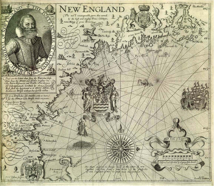
The main goal of Smith’s expedition was to catch whales and look for gold but also to scout for a location to establish an English colony in New England.
Sailing along the coastline, Smith recorded his observations in a manuscript, later published under the title A Description of New England, in which he describes the coast of Massachusetts:
“Betwixt Sagadahock and Sowocatuck there is but two or three sandy bays, but betwixt that and Cape Cod very many; especially the coast of the Massachusets is so indifferently mixed with high clay or sandy cliffs in one place, and then tracts of large long ledges of diverse forts, and quarries of stones in other places so strangely divided with trinctured veins of diverse colors: as, free stone for building, slate for tiling, smooth stone to make furnaces and forges for glass or iron, and iron ore sufficient, conveniently to melt in them; but the most part so resembles the coast of Devonshire, I think most of the cliffs would make such limestone” (Smith 6.)
During the expedition, Captain Thomas Hunt, a lieutenant for Captain Smith, captured 23 natives, one of whom turned out to be Squanto, and took them to Spain where he sold them as slaves.
Squanto later made his way back to New England, in 1619, as an interpreter for Captain Thomas Dermer before eventually meeting the Mayflower pilgrims in 1621.
For more information on Smith, check out this timeline of Captain John Smith’s life.
Sources:
Smith, John. A Description of New England. George P Humprey, 1898.
Champlain, Samuel de. Voyages of Samuel de Champlain, 1604-1618. Charles Scribner’s Sons, 1907.
“Champlain and the Settlement of Acadia, 1604-1607.” University of Maine, umaine.edu/canam/publications/st-croix/champlain-and-the-settlement-of-acadia-1604-1607/
“Bartholomew Gosnold: The Man Who Was Responsible for England’s Settling the New World.” British Heritage, 4 Oct. 2006, britishheritage.com/bartholomew-gosnold-the-man-who-was-responsible-for-englands-settling-the-new-world/
“Batholomew Gosnold, the Founding Grandfather of the 13 Colonies (and Namer of Cape Cod).” New England Historical Society, www.newenglandhistoricalsociety.com/bartholomew-gosnold-the-founding-grandfather-of-the-13-colonies-and-namer-of-cape-cod/
“Giovanni da Verrazzano, Letter to King Francis I of France, 1524.” National Humanities Center, nationalhumanitiescenter.org/pds/amerbegin/contact/text4/verrazzano.pdf
“Our Maine Ancestors.” Penobscot Maritime Museum, penobscotmarinemuseum.org/pbho-1/our-maine-ancestors/timeline-major-explorers
Unaware of Sieurs de Monts exploits.