
Ring’s Island is a peninsula in Salisbury, Massachusetts located near the mouth of the Merrimack River.
On March 26, 1642, two acres of Ring’s Island was granted to colonist Robert Ring for the purpose of fishing. Ring was a servant of John Sanders and came to Salisbury in 1638 when the town was first settled.
Robert Ring was a fisherman and a cooper and he used the island to dry codfish, which he stored in wooden kegs that he built himself. Ring built his house on the island on the site that is now occupied by 35 First Street.
The second land grant on the island was awarded to Michael Hodge and included land along the Merrimack River from the boat launch at the corner of First and Second Street west to where the Newburyport Railroad Bridge crosses Friedenfels Road. Hodge built fishing schooners on the island and built his house near what is now the boat launch.
The third land grant on Ring’s Island was given to colonist Tristram Coffin. The land extended from what is now Second Street to Mill Creek.
Tristram left Salisbury for Nantucket in 1659 but the land remained in the Coffin family for many generations. The family operated a tide mill to grind corn on Mill Creek and built boats in shops located on their land.
In the 1650s, Ring’s Island was still used primarily for fishing and housed many stages and fish flakes (fish drying racks) for drying cod. Shell fishing was also conducted on the island in the extensive shellfish beds that are located at the mouth of the Merrimack River and along the coast.
Also located in this area, near the mouth of the Merrimack River, are a total of 13 shell heaps believed to have been created by Native-Americans. The shell heaps are about a mile from the left bank of the Merrimack River, near its mouth, and are surrounded by sand dunes (Wyman 568.)
The shell heaps vary in size from about twenty feet to more than one hundred feet in diameter. The shells form a layer of only a few inches and are mixed with sand. During the 19th century, visitors often picked though the shell heaps and found arrowheads, broken pieces of pottery and stone tools.
Sometime around 1680, the Jonathan Dole House was built on land given by Robert Ring to his daughter Mary upon her marriage to Dole in 1680. The house is a Colonial saltbox house, located at 5 Third Street, and is one of the oldest remaining structures on the island.
The first street laid out on the island was Ferry Road in 1687-9, which is believed to have been a Native-American trail used by the Penacook tribe.
Also in 1687, Newbury tavern keeper John March was granted the right by Governor Edmund Andros to operate a ferry from the foot of State Street in Newburyport to Ring’s Island.
In 1690, the Joseph March Tavern, a Colonial-style house, was built at 16 Second Street for the grandson of John March. It is said that you can the shell-heaps on the banks of the river from this house.
In April of 1692, Jarvis Ring and Joseph Ring, sons of Robert Ring, accused Salisbury native Susannah Martin and Thomas Hardy of Maine of witchcraft during the Salem Witch Trials.
In May of 1692, Robert Pike, Salisbury resident and Assistant to the Massachusetts General Court, recorded Joseph Ring’s testimony, during which Ring described being confronted by Thomas Hardy, whom he owed a small debt to, and a group of mysterious creatures on horseback near Rye, New Hampshire in June of the previous year and again 10 days later near Newbury, Mass and then again at the Salisbury Plain Pines while returning from Hampton Beach in October.
Ring also said that in September he was chopping timber in the woods with his brother when Thomas Hardy suddenly appeared and asked him to follow him to Benoy Tucker’s house, which was deserted and about a half mile away, and upon doing so he saw Susannah Martin drinking by a fire with some other witches but he said she later transformed into a black hog and fled.
Jarvis Ring’s testimony described being attacked by Susannah Martin’s spirit while laying in his bed about seven or eight years previous.
Susannah Martin was tried in June, found guilty and executed on July 19, 1692. Thomas Hardy was not convicted. Joseph Ring died 12 years later in 1704, during Queen Anne’s War, when he was captured by Native-Americans during a raid in Berwick, Maine, possibly while working as an unofficial soldier or bounty hunter collecting Native-American scalps, and was tied to a stake and burned alive (Penhallow 23; Ring, 2006.)
Ring’s Island During the 18th Century:
The majority of the houses on Ring’s Island were actually built during the 18th and 19th centuries.
In 1734, the Elias Pike House, a Colonial-style house, was built at 15 Second Street.
In 1740, the Mrs. Mary Pike Graves House, a Colonial/Georgian-style house, was built at 11 Fourth Street and the William Gerrish House, a Georgian-style house, was built at 6 Third Street.
In 1750, the Everett E. Skinner Store, a Queen Anne-style house, was built at 22 First Street and the Joseph March House, a Georgian-style house, was built at 13 Second Street.
In 1752, the Captain John March House, a Colonial-style house, was built at 11 Second Street.
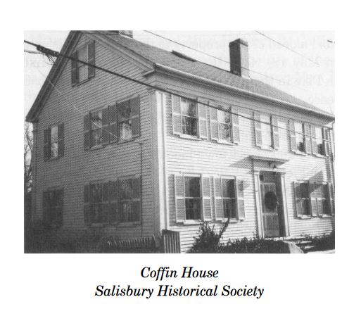
In 1760, the Stephen Coffin House, an Italianate-style house, was built at 2 Second Street.
In 1770, the James Cartwright House, a Greek Revival-style house, was built at 24 First Street.
In 1780, the Captain Sawyer House, a Federal-style house, was built at 3 First Street and the John Jones House, a Georgian/Federal-style house, was built at 9 Fourth Street.
In 1790, the Joshua Moody Pike St House, a Georgian/Colonial-style house, was built at 9 Second Street.
In 1799, the Bert Rowe House, a Federal-style house, was built at 35 First Street.
Ring’s Island During the 19th Century:
In 1800, the John S. Morse House, a Federal-style house, was built at 18 First Street and the Joseph Warren Currier House was built at 2 Third Street.
In 1820, the True Green Graves House was built at 25 First Street and the Captain Elias Dole House, a Dutch Colonial-style house, was built at 29 First Street.
In 1827, First Street was laid out when Bridge Road was constructed and a wooden covered bridge was built across the Merrimack River to connect Salisbury to Newburyport.
In 1835, the Amos B & John M. Coffin House, a Federal-style house, was built at 6 Second Street.
In 1840, the Captain John March house, a Colonial-style house, was built at 11 Second Street.
In 1849, the Gerrish brothers began construction on their house, now known as the Mary Coffin Gerrish House, which is a Greek Revival-style house located at 10 Second Street. The house was nearly completed when the brothers left later in the year to mine for gold in California during the Gold Rush of 1849.
In 1850, the John S. Morse/Mary Rich House was built at 17 First Street.
In 1852, the Gerrish brothers return to Ring’s Island and completed the Mary Coffin Gerrish House with the money they earned gold mining in California.
In 1860, the Henry Rich House was built at 11 First Street and the Joseph Perkins House, a Greek Revival-style house, was built at 5 Fourth Street.
In 1861, a house was built at 21 First Street.
In 1866, the Newburyport Railroad Bridge, which is a stone-arch bridge, was built over Freidenfeld Road for the Eastern Railroad line, making it the oldest document stone-arch bridge on the Eastern Railroad main line.
First Street remained a footpath until 1869 when the town purchased the land from the Dole family to build a schoolhouse and improved the road.
In 1870, the Emma Dole House, a Greek Revival-style house, was built at 31 First Street.
In 1872 the Edward E. French House, a Vernacular-style house, was built at 7 Second Street.
In 1874, the March School was built on Fourth Street.
In 1878, the Captain William Morgan House, an Italianate-style house, was built at 28 First Street.
In 1880, a house was built at 25 March Road.
In 1890, the Joseph Pasquale House, a Second Empire-Style house, was built at 15 First Street and the Henry W. Woodard House, a Federal-style house, was built at 3 Fourth Street.
In 1892, the Union Chapel was built at Fourth Street.
In 1895, the Bert Rowe House, a Queen Anne/Italianate-style house, was built at 33 First Street.
In 1898, the George Stone House, an Italianate-style house, was built at 9 First Street.
In the late 19th century, the Hogdon House was built at 27 First Street and the Joseph Perkins House was built at 30 First Street.
Also, sometime in the 19th century, the Perkins Boat Shop was built at 7 Fourth Street and the Captain Samuel Francis Pike House was built at 5 Second Street.
Ring’s Island During the 20th Century:
In 1900, Rich’s Store, a Colonial Revival-style commercial building, was constructed at 13 First Street, the Eugene Hawkes House was built at 19 First Street and the Everett E. Skinner House was built at 20 First Street.
In 1902, the Arthur Fernald House was built at 7 First Street.
In September of 1918, the March School on Ring’s Island, along with the other schools in Salisbury, closed temporarily due to the Spanish Flu epidemic.
The March School closed in 1928 and the building was converted into the Fourth Street fire station in the 1930s.
In 1930, the Charles T. Hopkinson House, a Colonial-style house, was built at 14 Second Street.
In 1932, the Anthony and Helen Caramango House, a Colonial Revival-style house, was built at 5 First Street.
In 1972, the Andrew J. Gillis Memorial Bridge was built over the Merrimack River on Route 1.
On February 6, 1978, the infamous Blizzard of 78 struck New England causing 14-foot tall waves on Salisbury Beach. Major flooding occurred on North End Boulevard, Atlantic Avenue and Railroad Ave on the beach and cellar homes on Ring’s Island, Ferry Road and Bridge Road were flooded.
The storm last two days and it took over a week to clean up all the snow and debris. U.S. Representative Michael Harrington, State Representative Henry Walker, Deputy Commander Albert Zabriskie, Selectman Alfred Sargent and Walter Morse and Harmon Guptil of the U.S. Army Corp of Engineers toured Ring’s Island, Plum Island and Salisbury Beach to survey the damage and estimated Salisbury’s damage at 9.2 million dollars (Sargent 86.)
For most of the 20th century, very little construction took place on the island and it has only been within the past decade that several new homes were constructed.
Sources:
Sargent, Carolyn. Salisbury History. Salisbury Historical Commission, 1991
Penhallow, Samuel. The History of the Wars of New England with the Eastern Indians. Wm Dodge, 1859.
Wyman, Jefferies, M.D. “An Account of Some KJEKKENMEDDINGS, or Shell-Heaps, in Maine and Massachusetts.” The American Naturalist, Vol 1. No. 11, January, 1868, jstor.org/stable/pdf/2446746.pdf
Ring, Wilson. “Who was Joseph Ring and why was he killed?” Telegram & Gazette, 26 March. 2006, telegram.com/story/news/local/north/2006/03/27/who-was-joseph-ring-why/53115542007/
Sullivan, Jim. “Ring’s Island residents want preservation district.” The Daily News, 13 May. 2019, newburyportnews.com/news/local_news/rings-island-residents-want-preservation-district/article_934e225e-ae12-57be-8c7f-affd34c47d02.html
“Robert Ring, Home Site of.” Salem Witch Museum, salemwitchmuseum.com/locations/robert-ring-home-site-of/
“Testimony of Jarvis Ring v. Susannah Martin.” Salem Witch Trials Documentary Archive and Transcription Project, salem.lib.virginia.edu/n92.html#n92.13
“Deposition of Joseph Ring v. Susannah Martin and Thomas Hardy.” Salem Witch Trials Documentary Archive and Transcription Project, salem.lib.virginia.edu/n92.html#n92.14
SWP No. 092: Susannah Martin Executed July 19, 1692.” Salem Witch Trials Documentary Archive and Transcription Proect, salem.lib.virginia.edu/n92.html
MHC Reconnaissance Survey Town Report: Salisbury. Massachusetts Historical Commission, 1985, sec.state.ma.us/mhc/mhcpdf/townreports/Essex/sls.pdf
“SLS.911 Newburyport Railroad Bridge over Freidenfeld Road.” MACRIS, mhc-macris.net/#!/details?mhcid=SLS.911
“SLS.D Rings Island.” MACRIS, mhc-macris.net/#!/details?mhcid=SLS.D
Thank you for doing this work. Its excellent! I am working to save the Union Chapel and March School House from being drastically changed. I live in the Dole House at 5 Third. The street used to be called, “Way to the Meeting House Lane, and 4th St was Dole Lane. I have a petition on change.org
I would be interested in any and all information about Ring’s Island, including the contents of Ms. Noonan’s book which, I’m told is in the Archives of the Newburyport Library. I am a descendant of Henry Rich, Jonathan Dole, and Joel Hodgdon, among others. I do know that my grand-uncle, Herman Rich was arrested for rum running at Salisbury Beach along with 24 Salisbury police officers, chief Congdon, and the Salisbury mayor during prohibition.
This is such an interesting article! I’d be curious to know who George Stone of Ring’s Island was. How would I research that?
I found the name of the house on the MACRIS website. There is usually a file on each house and it will tell you more about the background of the house and the various owners. You could also try ancestry.com or some of the history books about Salisbury.