
Dogtown is a historic ghost town on Cape Ann on the North Shore of Massachusetts. It is a rocky, undeveloped area located in both Gloucester and Rockport and is nearly 3,000 acres in size. It is noteworthy for its history as well as its geological features.
The central part of Dogtown has shallow rocky soil, while the southern part of Dogtown is strewn with giant boulders, which were placed there by the southern end of a glacier and are considered an excellent example of a terminal moraine (the furthest point of a glacier’s advance.)
The site is also home to a number of interesting geological features such as uniquely shaped boulders like the Whale’s Jaw and Peter’s Pulpit.
Dogtown in the 17th Century:
The earliest settlements in Dogtown occurred in the 1630s and 1640s, when several mills were established along Cape Pond Brook.
The first mill established there is now known as First Mill and was constructed just east of the Babson Reservoir in 1635. The second mill is known as Second Mill and was established just west of Babson Reservoir in 1644. The third mill is known as Alewife Mill and was established just east of the First Mill at an unknown date.
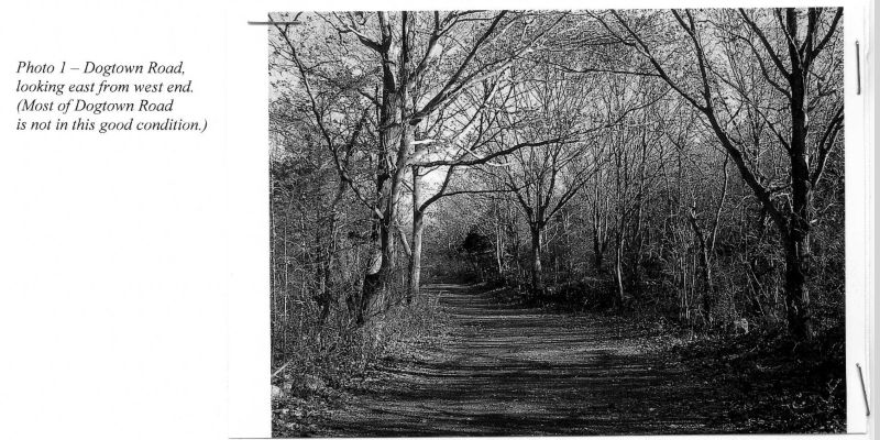
There were two main roads in Dogtown: one called Dogtown Road, which extends east from modern-day Cherry Street, and the other is Commons Road, which is located between the reservoir and a secondary road called Wharf Road. There is another secondary road called Back Road that is located off of Cherry Street.
The first land grant in the Dogtown area was awarded to James Babson in 1658 for 32 acres. Babson was a farmer who built a small stone cooperage in Dogtown that still stands today and currently operates as a history museum called the Babson Museum.
Between 1658 and 1750, there were 60 families living in Dogtown, mainly on walled-in farms along Dogtown Road and Commons Road. It wasn’t originally called Dogtown at the time it was settled and instead was called the Commons Settlement.
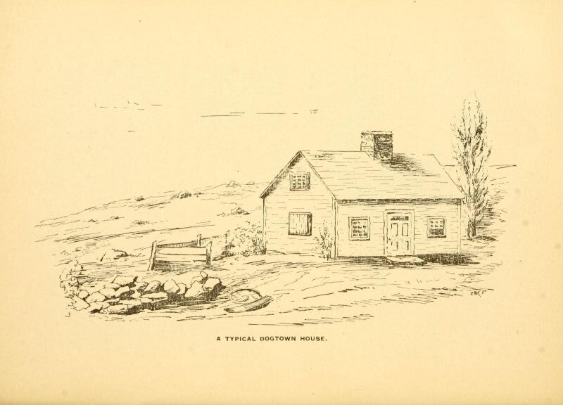
The houses on these Dogtown farms were typically one-story wooden buildings, about 15 feet by 35 feet in size, with a door in the middle, a pitched roof, and a partial stone cellar about 15 feet square in size, which was used to store food. Not all of the houses in Dogtown fit this description, though. Some were two-story, and one had a gambrel roof.
Most of the families living in the settlement were prosperous families, and the settlement was considered a prestigious place to live at the time.
Dogtown in the 18th Century:
In addition to their farms, these families were also later awarded “cow rights” on a large tract of over 1,000 acres known as the Commons Pasture and “wood lots” near this pasture.
The Commons Pasture was an area of several square miles located entirely in Gloucester roughly north of Commons Road, south of Dennison Street, and east of Goose Cove. The pasture was initially wooded when Dogtown was first settled but had been cleared by the early 18th century and was used as communal grazing land.
Northeast of the pasture were the wood lots, which were divided into 136 long, narrow lots that were established in 1722. The lots were individually owned and were used for cutting timber.
By 1740, the population of Dogtown was about 25 families. According to Roger Babson in his book Dogtown: Gloucester’s Deserted Village, the decline of Dogtown began in 1750 when some of the residents decided to give up farming and instead focused on the fishing and shipping industry. To do so, they moved out of Dogtown and relocated closer to Gloucester Harbor.
Yet, the 2005 Gloucester Reconnaissance Report by the Massachusetts Department of Conservation and Recreation says that the population gradually declined after the Revolutionary War.
Some residents of the harbor village actually moved to Dogtown during the Revolutionary War for safety. In 1775, the Foster family moved with their 8-year-old daughter, Dorcas Foster, to a house on Dogtown Road because Dorcas’ father feared Gloucester might be raided by the British Navy, and he wanted to keep his family safe when he was away at war.
Dorcas and the other Dogtown children were often sent to the harbor village for supplies. Dorcas reportedly became terrified one day when she saw a group of Continental soldiers that she mistook for British soldiers. She panicked and began to run, but the soldiers reassured her that they were not the enemy (Mann 45.)
After the Revolutionary War battles in New England ended in 1776 and the threat of pirates and privateers in the area was eliminated, it finally became safe to live at the harbor.
As families moved out of the Commons Settlement, the ones that remained were typically less affluent. More low-income residents soon began to relocate to the Commons Settlement to live in the existing homes there. The settlement soon began to attract vagabonds, derelicts, and outcast women who were rumored to be witches.
Dogtown in the 19th Century:
Yet, some affluent residents still chose to live in Dogtown due to its safety during wartime. Colonial William Pearce, one of the wealthiest men in Gloucester, sought refuge from the threat of attack by British ships during the War of 1812 by moving to a house on Dogtown Road where he kept a large flock of sheep. In fact, in June of 1814, some of his prized sheep were stolen by British raiders at Annisquam Harbor.
By the early 19th century, though, Dogtown had become lawless, and many of the residents owned dogs to protect themselves (hence the name Dogtown.) Due to neglect and a lack of money, the remaining houses quickly began to deteriorate and fall apart.
By 1814, only six of the original 60 homes were left standing. Of these 60 homes, only the ones that had cellars could be identified, of which there are only 40.
In the winter of 1814, Dogtown resident Abraham Wharf, who lived in a large gambrel-roofed house at the junction of Commons Road and Dogtown Road, was struggling with loneliness and depression in the deserted town.
Wharf asked his sister one day, while he was sharpening his razor by the fire, “Do you think people who commit suicide go to heaven?” “I don’t know,” she answered. “But I hope you will never do such a thing, brother.” “God forbid,” was his response. He then discreetly slipped the razor in his shoe, went outside, crawled under a nearby boulder, and took his own life (Mann 54.)
Sometime prior to 1820, Dogtown resident John Clark died, and his wife and children relocated to the harbor. In 1820, the Clark house on Dogtown Road had become so dilapidated that it was torn down.
By 1830, only one resident remained in Dogtown, an African-American man named Cornelius Finson who lived in the house of one of the original inhabitants, Judith Ryon, on the road leading from Gee Avenue in Riverdale to Dogtown.
Finson had been friends with two other inhabitants, suspected witches Judy Rhines and Molly Jacobs. When Jacobs was taken to the almshouse, he was convinced she had left buried treasure in her cellar. He moved into her old house, which had become dilapidated due to the roof caving in, and lived in the cellar, which he searched extensively but never found any treasure.
His friend, Judy Rhines, lived nearby and took pity on him and invited him to live in her house. After Rhines died, Finson continued living in her house until that house eventually collapsed too, and he sought refuge in the cellar.
One day, in the winter of 1830, Constable William Tucker of Riverdale carried Finson out of the frozen cellar, cold and half-starved, and brought him to the almshouse, where he died a week later (Mann 51.)
In 1845, the last house in Dogtown, the home of Annie Carter on Dogtown Road, was torn down (Mann 43.) Dogtown continued to be used as open pasture land for cows and bulls as well as for picnicking and berry picking by locals.
The natural scenery of Dogtown also began to attract outdoor enthusiasts such as Henry David Thoreau, who visited with a friend in 1858.
On August 30, 1892, it was reported in the Boston Traveler that a modern cottage had recently been constructed on Dogtown Common, although it’s not clear who built it:
“A handsome modern cottage has just been erected on Dogtown Common, in Gloucester, directly opposite the clump of barberry bushes growing in the ancient cellar of Tammy Younger…”
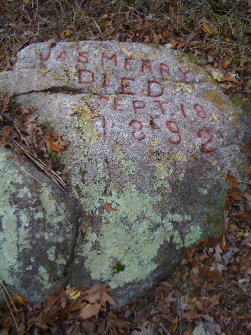
On September 18, 1892, a local man named James Merry was gored to death by a bull while berry picking in a small pasture in Dogtown.
Three men, Isaac Day and Henry and Chester Norwood, were walking along Commons Road when they discovered Merry’s body between two rocks after they spotted a bull nearby with blood on its horns.
A large wound was found on Merry’s abdomen, and it was assumed he had been gored to death by the bull. Although local legend states that Merry was an amateur bullfighter and that he raised the bull himself so he could practice his bullfighting skills, this is not true.
An 1892 news report in the Daily Evening Item stated that the bull was actually owned by Patrick Nugent and that it attacked James Merry when he was berry-picking in the pasture.
About a week after Merry died, two local men, Raymond Tarr and D. K. Goodwin, engraved two boulders near where Merry was found. The boulders, known as the Merry Boulders, were engraved with the words “First Attacked” and “Jas. Merry died Sept. 18, 1892” to mark the spot where James Merry had been killed by the bull.

In 1896, historian Charles Mann published In The Heart of Cape Ann, or The Story of Dogtown, which was the first major history written about Dogtown. Mann was one of the first people to officially use the name Dogtown.
Dogtown in the 20th Century:
In 1927, local millionaire and famed statistician Roger Babson and his cousin Gustavus Babson purchased 1,150 acres of land in Dogtown, where their Babson ancestors had once lived, and began cataloging the cellar holes of the houses that once existed in the old settlement.
Roger Babson also wrote a guidebook to Dogtown in 1927, which was based on a speech he gave to the Gloucester Rotary Club that year.
In 1929, Babson hired stonecutters to carve inspirational quotes and sayings into the local boulders scattered across Dogtown, which later came to be known as the Babson Boulders.
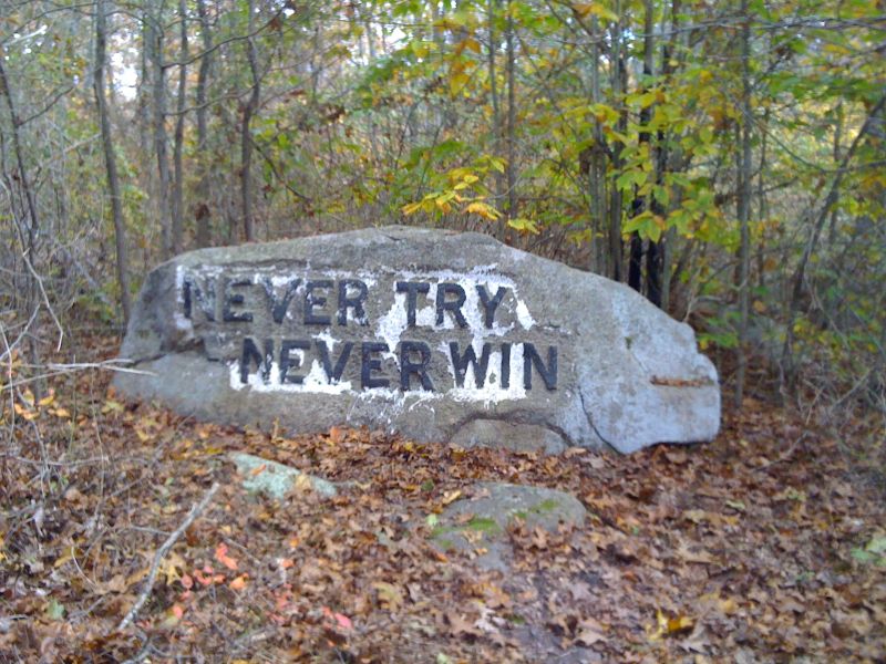
The boulders were engraved with sayings such as “Help Mother” and “Never Try, Never Win.” One such boulder, engraved with the words “Spiritual Power,” is reported to be the boulder where Abraham Wharf took his own life in 1814 (Saxe 1939.)
In 1930, Babson donated this land to the City of Gloucester to establish a reservoir, known as the Babson Reservoir, on the stipulation that the area would forever be kept as a public park.
In 1931, Maine artist Marsden Hartley spent the spring and summer at Dogtown, writing a series of poems and creating oil paintings of the area.

In the 1940s, MIT Professor Frederick Norton excavated some of the cellar holes in Dogtown, such as cellar holes of the Clark family, Joseph Winslow, James Dermerit, Colonel Pearce, and Peter Lurvey, and donated the artifacts he found to the Sandy Bay Historical Society.
Some of these artifacts included fragments of native redware, imported English earthenware, and Chinese porcelain stoneware from Staffordshire, England.
On May 21, 1956, a 13-year-old boy, Walter Henry Muse, was shot and killed by his friend, 14-year-old Henry Douglas Merchant, on Dogtown Common. Merchant was charged with delinquency by virtue of manslaughter.
In 1958, a legislative study group considered establishing a nuclear fuel processing plant on Dogtown Common, among other places, but rejected the idea in favor of building it at Camp Edwards in Cape Cod instead.
In 1960, the Dogtown Foundation Inc. formed to pressure the City of Gloucester into seizing 600 acres of land in Dogtown by eminent domain to add to the public park.
In 1961, the City of Gloucester proposed that NASA build its $60-million-dollar Project Apollo moon-shot laboratory in Dogtown. Officials from the Massachusetts Citizens Committee for Project Apollo visited Dogtown that year to assess the site. The moon lab project was later awarded to Houston, Texas.
In 1963, Dogtown Common was seized by eminent domain to establish the Goose Cove Reservoir at the western edge of Dogtown, which resulted in several cellar holes along Commons Road being submerged but also added 600 acres of land to the public park.
On June 24, 1984, a 39-year-old school teacher, Anne Natti, was found brutally murdered on a trail in the wooded area of Dogtown Common, and a local sex offender, Peter Hodgkins Jr., was arrested and sentenced to life without parole for the crime.
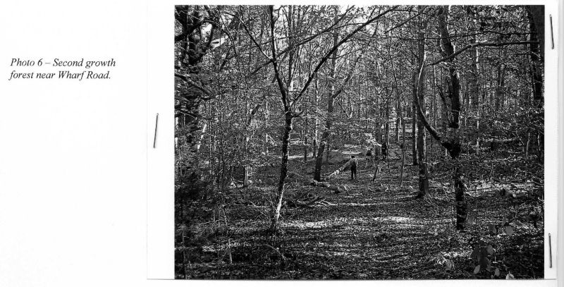
Most of the original Commons Pasture is now second-growth forest with areas of swamp and a few hiking trails established in the 20th century.
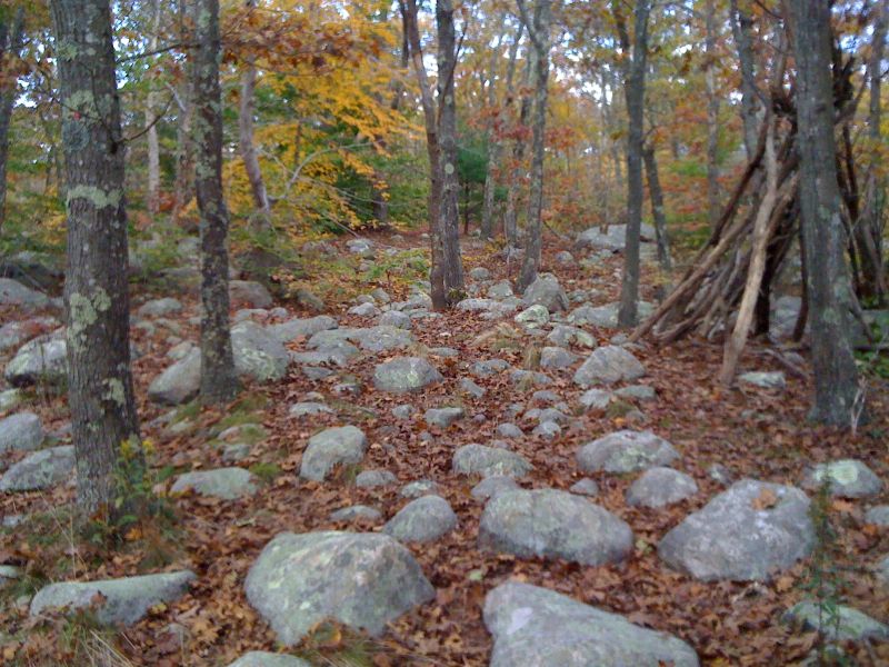
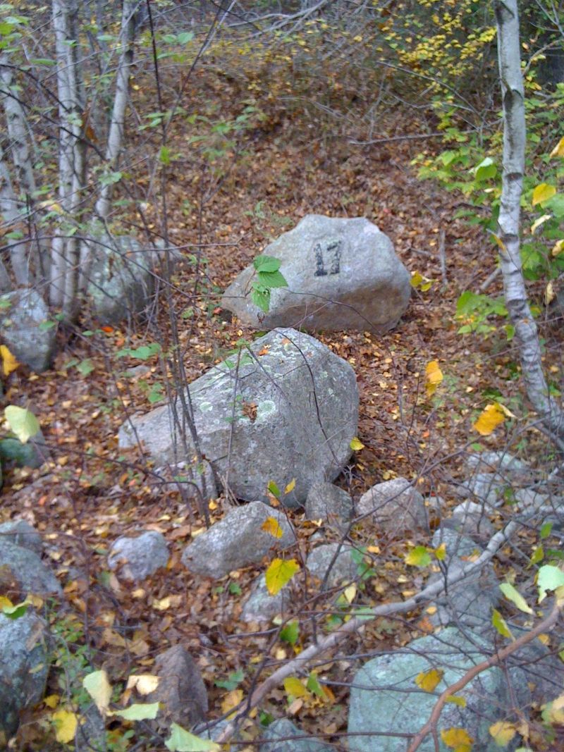
The cellar hole markers of the original inhabitants and the Babson Boulders still remain and are numbered and mapped out for visitors to explore.
Index of the Cellar Holes:
Back Road (starting from Cherry Street):
1. Nathaniel Day
2. Becky Rich
3. Molly Millett
4. Emmons Family
5. Mussey Family
6. Smith Family
Dogtown Road (Starting from Cherry Street):
7. Benjamin Stanwood
8. Jeremiah Millet
9. Clark Family
10. Arthur Wharf
11. Phillip Priestley
12. William Wilson
13. Joseph Winslow
14. Hannah Stevens
15. Easter Carter
16. James Dermerit
17. Dorcas Foster
18. Isaac Dade
19. Joseph Ingersoll
20. Widow Day
21. Stephen Robinson
22. Joseph Riggs
23. Colonel Pearce
Wharf Road (Connecting Dogtown Road with Commons Road):
24. Abram Wharf
25. Peter Lurvey
Commons Road (Starting from the junction of Gee Ave and Stanwood Street):
26. Stanwood House
27. “The Castle”
28. Bennett Farm
29. Hilton Place
30. Joseph Hunter and cobbler shop
31. Jim White
32. Ann Davis
33. Esther Wharf
S. Nehemiah Standwood
W. James Wharf
34. Unidentified
35. James Wharf, Sr
36. Whipple Family
37. Wither Family
38. White Family
39. Benjamin Allen
40. Unidentified
The other 1,400 remaining acres of Dogtown are still privately owned.
Sources:
Mann, Charles E. In the Heart of Cape Ann, or, The Story of Dogtown. Proctor Brothers Publishers, 1896.
Babson, Roger. Dogtown: Gloucester’s Deserted Village. Leo A. Chisholm, 1927.
Gloucester Reconnaissance Report. Massachusetts Department of Conservation and Recreation, May 2005.
“Dogtown.” Gloucester, MA – Official Website, gloucester-ma.gov/960/Dogtown
“James Merry.” Gloucester, MA – Official Website, gloucester-ma.gov/717/James-Merry
“Whale’s Jaw.” Gloucester, MA – Official Website, gloucester-ma.gov/712/Whales-Jaw
“Historic Area Detail: GLO.AA Dogtown.” MACRIS, mhc-macris.net/details?mhcid=GLO.AA
“A Ruined Town.” The Boston Herald, 1 Aug. 1875, p. 2.
“Killed by a Bull.” Daily Evening Item, 19 Sept. 1892, p. 5.
“The Gossiper.” The Boston Traveler, 30 Aug. 1892, p. 8.
Brayley, Arthur. “Cape Ann Has a Real Deserted Village.” The Boston Globe, 8 Aug. 1926, p. 60.
Davis, Freda. “Deserted Village of Witches To Be Made Beauty Spot.” The Boston Herald, 18 Jul. 1926, p. 66.
“Boston Millionaire Deserts Civilization to Live With Birds in Wilderness of Witches and Pirates.” Boston Sunday Post, 28 Jul. 1929, p. A-6.
Rabbette, Leo. “Water Basin Operation Recalls Witch’s Curse.” The Boston Globe, 20 Jan. 1931, p. 13.
“Woman Resents Carving of Babsonian Maxims on Dogtown Common Rocks.” The Boston Herald, 8 Jul. 1932, p. 1.
Saxe, Arthur M. “Sermons in Stones.” The Boston Herald, 30 Jul. 1939, p. 45.
“Killing Termed ‘Wanton Act.’” Fall River Herald News, 14 Jun. 1956, p. 19.
“Freetown Rejected As Nuclear Fuel Plant Locale.” Fall River Herald, 30 Dec. 1958, p. 17.
“Dogtown Common.” The Boston Globe, 3 Sept. 1958, p. 30.
“On Beacon Hill.” The Reading Chronicle, 28 Jan. 1960, p. 4.
Kenny, Herbet A. “Cape Ann Moves to Save Romantic Ghost Town.” The Boston Globe, 20 March. 1960, p. 84.
“Citizens’ Group Campaigns For Bay State Moon Lab.” The Boston Globe, 12 Aug. 1961, p. 2.
“Rockport Favors Moon Lab Here.” Gloucester Daily Times, 19 Aug. 1961, p. 1.
“Press Confab on Moon Lab.” Gloucester Daily Times, 26 Aug. 1961, p. 1.
“Moon Lab Group Gets Rough Ride.” Gloucester Daily Times, 30 Aug. 1961, p. 1.
“Space Center Not Sewed Up; North Shore is Still in Race.” Gloucester Daily Times, 27 Mar. 1963, p. 1.
“Could We Land Space Center.” Gloucester Daily Times, 19 Jan. 1963, p. 1.